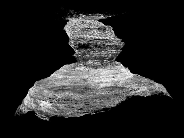
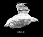
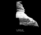
Lidar mapping and surface of Devil's Sink hole
This is a detailed 3D (3- to 4-cm point spacing) laser map of a stunning geological feature
of the Edwards Plateau. The purpose of this multifaceted study includes public outreach for
the Devils Sinkhole Natural Area, and it offers quantitative data for geological and biological
studies of karst and karst-hosted aquifers, as well as cave research. The data collected
provide insight into the relative timing of the formation of the sinkhole and may provide
additional analog data for modeling of subsurface paleokarst systems.
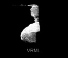
Devils Sinkhole, located northeast of Rocksprings in Edwards County, Texas, was "discovered"
in 1867 and is a registered National Natural Landmark. This exquisite karst feature of south-
central Texas offers a chance to observe a near-vertical >100-m (>325-ft) stratigraphic
section of the Lower Cretaceous, lowermost Washita and Edwards Groups.
The depth of the sinkhole 107 m (351 ft) has earned its standing of third-deepest cave in Texas.
The anomalous cave depth reaches below the water table, making it ideal for Edwards aquifer
monitoring. The underground freshwater lakes around Devils' perimeter support two unique
crustacean species an endemic amphipod and a rare aquatic isopod. The walls of the sinkhole
support a Mexican fern species found in few other locations in the United States. A seasonal
population of Brazilian freetail bats leaves the sinkhole each night to forage for insects.
In the bat "off-season," a population of three to four thousand cave swallows inhabits the
sinkhole. Because access to the pit is restricted, the lidar model will allow visitors to
experience Devils from the inside out and to take virtual tours from a bat's eye view.
Lidar scanning, mapping and research of this data set by Jerome A. Bellian
Surface rendering and 3D point cloud processing by Reuben Reyes
This project was funded by a grant from contributions by:
Texas Parks and Wildlife Department Texas Cave Management Association
National Speleological Society National Cave and Karst Research Institute
Devils Sinkhole Society George Veni and Associates
Daniel Holman Photography Kevin McGowan Photography
Pigeon Mountain Industries Bat Conservation International
Will Howie Jerry Atkinson
Don Auburn
| How to view VRML models? |
You will need a VRML viewer or VRML client for your browser in order to view VRML models.
For Windows use Cortona, Blaxxum, Octaga or Cosmo. For Mac OS X use Cortona. For SGI Irix use Cosmo and for Linux use Octaga.
|
BEG RCRL